By Murray Wennerlund published 11-16-2024 updated 11-16-2024
|
|
|

By Murray Wennerlund published 10-11-2017 updated 3-10-2023
Azw3

By Murray Wennerlund published 10-11-2017 updated 3-10-2023
Azw3
Not always according to the FIRM (Flood Insurance Rate Maps) online. †1
Zone X Shaded is greater than or equal to the 0.2% (500 year) annual flood predictions.
Zone X Unshaded is less than or equal to the 0.2% (500 year) annual flood predictions.
Your formulas:
If Zone X >= 0.2 Then Zone X is Shaded
If Zone X <= 0.2 Then Zone X is Unshaded
The most important part of understanding the Flood Insurance Rate Maps is learning the legend.
From the LSU Ag Center FIRM Legend: ZONE X - Areas of 500-year flood; or 100-year flood with average depths of less than 1 foot or with drainage areas less than 1 square mile; and areas protected by levees from 100-year flood. †2
Another important lesson is to understand what the 100 year and 500 year flood predictions really mean.
100 year flood = 1% (One Percent) chance of a flood each year.
500 year Flood = 0.2% (zero point two percent) chance of a flood each year.
(Educated Guess, no actual data spanning 500 years for any given flood zone.)
1000 year Flood = Not enough data to determine. (Guess work / Engineers calculations / Opinion)
For more reading about percentage and predictions here are some resources.
USGS water.usgs.gov.
FEMA
What we have learned about FIRM Maps from experience.
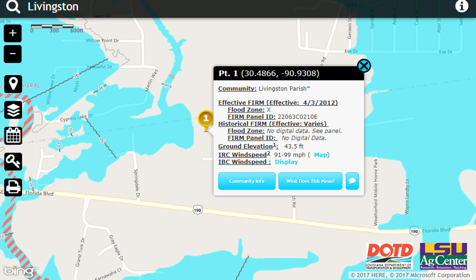
For our example, enter: 30.4866 -90.9308 into the search field at http://maps.lsuagcenter.com/floodmaps/

After you enter your search information (coordinates or street address) you will see a pin with a number appear on your map. Click or Tap the pin number to show information about this specific location.
In our example we see the flood zone type is Flood Zone X and we are in an unshaded area.
This for the most part would indicate that FEMA and the NFIP does not require you to carry flood insurance on your property and home. But, some mortgage lenders may require flood insurance do to the proximity to other flood prone areas.
The example we used is not unique or the exception.
The example is in a Flood Zone X Unshaded which is not required to hold flood insurance. But the home and surrounding properties did flood August 2016. It is estimated the this area had 20 inches to 32 inches of water in the homes based on ground elevation. If the home was elevated the water in the home during the August 2016 flood would be less than the 20 to 32 inch estimates.
FEMA does not require Zone X Unshaded to have flood insurance. But, some lenders may require flood insurance.
FEMA Document:
(https://www.fema.gov/faq-details/Flood-Insurance-Requirement )
If you have a question feel free to use the comment section.
References / Footnotes :